Christopher Mader laughs when thinking about his first test runs with drones. It was seven years ago and the data scientist at the University of Miami’s Institute for Data Science and Computing (IDSC) was constantly frustrated by the finicky, crash-prone devices. “It was almost a coin toss whether it would come back in one piece,” he said.
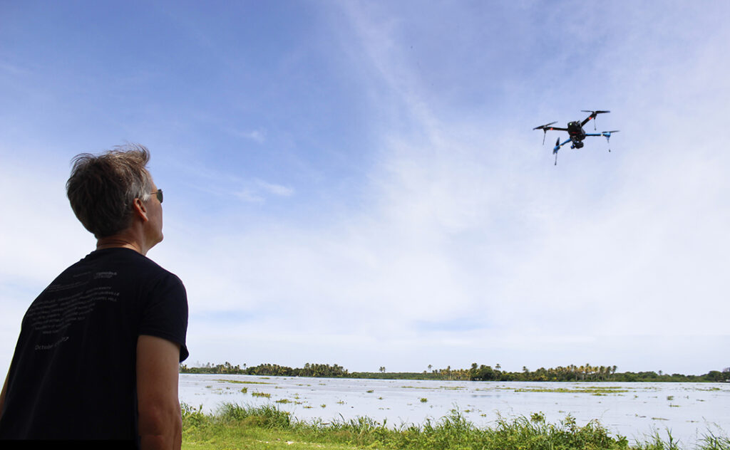
 But after years of advancements in drone technology, Mader and his team are using two high-tech unmanned aerial vehicles for an ever-growing list of projects. They create high-resolution maps of informal settlements in Latin America. They generate 3D recreations of historic buildings from Coral Gables to Curaçao. And now, Mader’s team is helping map activity in Miami-Dade County parks to enhance the health of the county’s residents.
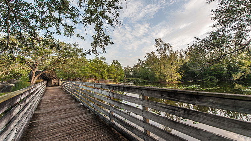
 Joanna Lombard, a Professor in the School of Architecture, and co-principal investigator Tyler Harrison, a Professor in the School of Communication, were awarded a $475,000 grant from the Florida Department of Health in Miami-Dade County to conduct the county parks project. The study calls for precise measurements of human activity in six parks at 72 different moments in time to gauge how they’re being used before and after a series of changes are made at three of the parks.
That work requires counting the number of people and cars in each park during each timepoint, a monumental challenge.
 Lombard calculated that for the largest parks, it could take over a dozen people assigned to different sections of each park to complete each survey, a time-consuming, labor-intensive process. That’s when they turned to Mader’s team at IDSC. They realized they could use drones to create highly-detailed, high-resolution maps of each park, with the potential to train a computer to count each person and car with each pass.
Lombard said that combination has made the activity counts less taxing, more accurate, and more useful. “These aren’t just small areas where we can say, ‘You take that half and I’ll take that half.’ You might need to have 15 people to cover multiple quadrants,” she said. “The drone flies over the whole park and you capture it in that moment of time. It resolves the issue of time and space by the instantaneous nature of what it does.”
The study builds on Miami-Dade County’s Parks and Open Space System Master Plan that calls for a transition from parks designed for a suburban, car-oriented culture to an interconnected series of parks better suited for the higher-density, pedestrian-friendly communities growing throughout the county. With the population in Miami continuing to grow, and the remaining open spaces in the county being gobbled up by developers, the county needs to maximize the 12,000 acres of park space it already operates.
 That’s where the UM study comes in. In the first series of surveys conducted in the spring, Mader and Timothy Norris, a data scientist at IDSC who specializes in drones, conducted 36 flights over six of the largest county parks to better understand how people use them. They then handed the images collected over to Abraham Parrish, a GIS Services Librarian who is tweaking computer vision software to combine the images and identify each person and car visible in the park.
 Mader said the drones generate thousands of individual snapshots, but the true power of Parrish’s work comes from the creation of one “orthomosaic image” covering the entire park. Created by stitching together overlapping images, orthomosaic images contain higher-resolution imagery than satellite images and are more precise than basic composite images.
That’s because basic composite images contain all kinds of distortions based on the angle from which each object is captured. For example, a building can appear to be leaning the farther they are from the center of the image. Orthomosaic images correct for those distortions using algorithms designed to “flatten” everything, creating a true sense of scale and distances.
“All of the buildings, you have the correct dimensions of them,” Mader said.
Working with the UM team, Miami-Dade County Parks department planners and county partners will then make changes to the infrastructure in and around each park. That will include new entry gates so that nearby residents don’t have to walk around blocks to enter or new crosswalks to make it easier for pedestrians to cross at the park’s entrance.
The IDSC team will conduct another 36 drone surveys later in 2022 to see how the changes altered the usage of each park. The end result, they hope, is a blueprint that can be replicated in other parks to maximize their efficiency to make it easier for residents to access parks and, ultimately, improve their health.
“These are neighborhoods that are underserved and have the most vulnerable populations,” Lombard said. “The disease burdens that those populations carry—diabetes, hypertension, obesity—these are things that we know have behavioral impacts.”
“Life is all of us inhabiting this place and living together, and when a team can come together like that, it’s so much richer.”
 The parks project also highlights a foundational principle of IDSC. Rather than each school and department at UM working independently, the Institute is pushing for more interdisciplinary projects that bring together experts in different disciplines who can bring unique approaches to each research project. In the case of the parks project, Mader and Norris represent IDSC, Lombard represents the School of Architecture, Harrison and colleagues Jennifer Miranda (photo not available) and Chris Koelsch represent the School of Communication, and Parrish represents UM Libraries. The team also includes faculty and students from the Miller School of Medicine and the Abess Center for Ecosystem Science and Policy.
“Life isn’t one intellectual construct,” Lombard said. “Life is all of us inhabiting this place and living together, and when a team can come together like that, it’s so much richer.”
The team will continue working on the parks project until they publish their results in 2023, but Mader is already looking ahead to using his drones on other collaborations at the University. He’s already working with the School of Architecture to produce a 3D rendering of the Coral Gables Congregational Church, across from the Biltmore Hotel, as the church’s 100th anniversary approaches. He’s talking with the University’s Facilities and Operations department to help them create a campus-wide map of every tree on campus. And he’s looking into adding multispectral and thermal cameras to his drones to measure heat maps in some of the most urbanized corners of Miami.
Mader said none of that would have been imaginable when he first started playing with his first drones. “Now they’re totally reliable,” he said. “These are really useful tools. They make people’s lives easier.”
Story by Alan R. Gomez
Tags: Abraham Parrish, Chris Koelsch, Chris Mader, Drone Mapping, Drone Survey, Drones, Jennifer Miranda, Joanna Lombard, Miami-Dade County Parks, Systems and Data Engineering, Tim Norris, Tyler Harrison